This post is the final instalment (for now) of a trilogy which began with identification of the location of a Tudor royal horse stud at ‘Eskermayne,‘ otherwise known as The Park, Park Penprise (plus variants) or Llys Pen Prys to the west of Caersws. The second instalment considered the broader historical context for horse breeding in Late Medieval and Early Modern Mid Wales, given that another major royal equestrian enterprise was probably located in Montgomeryshire (now North Powys) during the Tudor period. However, it is possible the latter (with stock numbers several times larger than Eskermayne – see discussion below) extended over more than one site forming, along with the Caersws operation, a strategic cluster Work by the historian Professor Maria Hayward of Southampton University (eg The 1542 Inventory of Whitehall: the palace and its keeper, vols 1 & 2 (Society of Antiquaries of London, 2004)), refers to: “Stud at Eskermayne, Wales Thomas Guilliam – in office in 1547… Stud in Wales Rice ap Moris – in office in 1547,” which seems to clearly link named keepers to the respective horse breeding operations. Whilst the identity of Guilliam has not been immediately accessible, it seems reasonable to deduce that Rice ap Moris refers to Rhys Ap Morris Blayney (1493 – 1568) who became High Sherriff of Montgomeryshire. He is linked to Aberbechan Hall (shown above) so the unknown stud location might have been in this vicinity, possibly extending to other sites in North Powys, a configuration that conforms with the Royal Armouries map discussed previously. In recent years, incidentally, Aberbechan has become associated with the family of well-know show jumper and sports horse producer Roland Fernyhough.
Further Discussion
In The History of the Countryside, the late Oliver Rackham notes that: “A disused park might revert to being a wood, often permanently acquiring the name ‘Park Wood’ (Chapter 6: Wood-pasture – Wooded commons, parks and wooded forests). Unfortunately, in this instance the mighty oaks described by writers of the Tudor period have been replaced by modern plantation, although some remnant of ancient woodland survives nearby and is discussed later. The entry for Caersws Park in the regional Historic Environment Record (HER) confirms this is a scheduled park and “was part of the Earl of Leicester’s holdings in the later 16th century” (thanks to Dr Gary Duckers of the Clwyd-Powys Archaeological Trust (CPAT) for the HER material). More information about the Robert Dudley landholding can be found in an archive compiled by Dr Robin Darwall-Smith of University College Oxford, including details of the ‘The Park and Eskermayne Estates.’ A very helpful email exchange with Professor Robert Liddiard of the Medieval Warhorse project confirms the probability that the Park and Eskermayne studs were one and the same, based on various accounts for stock numbers of around 100 (or, more precisely, 97 mares, 11 fillies, and 4 colts for Eskermayne in 1547). Investigation in to the possible larger Tudor royal equestrian project in Montgomeryshire has not to date been so fruitful, but Professor Liddiard provided ‘Wales’ stock numbers (so the responsibility of Professor Hayward’s keeper ‘Rice ab Moris’ for 1547) as: 12 stallions; 266 mares; 111 fillies; 98 colts. Hopefully, this strategic cluster might be the subject of further research.
Returning to Eskermayne or the Park at Caersws, is is perhaps surprising that the important Tudor equestrian connection is not more widely known locally, along with the site’s significant medieval history. Anyone who has visited the area will know that this still holds some of the numinosity associated with more famous and better conserved wood pasture landscapes of the kind explored by Oliver Rackham; and the Caersws Basin setting at the confluence of the Rivers Severn, Carno and Trannon is quite striking. CPAT’s 2015 scheduling enhancement programme describes the Park thus:
Two kilometres to the west of Caersws, and only a short distance to the north of the road that ran westwards from the Roman fort, Penprys lies immediately above the plain of the River Severn (about 1.5km to the east) where a small stream, the Colwyn Brook, drops to the valley. It thus has all the topographical hallmarks of a carefully selected location.…
The listing includes a discussion of the significance of Park (Llys Pen Prys) during the Medieval period:
Melville Richards suggested this as the original centre for Arwystli, with Talgarth becoming important only at a later date, while to Sir John Lloyd Caersws was the royal manor or court of Arwystli Is Coed (Arwystli below the Wood) No other references to the significance of this site have been encountered, but David Stephenson seems confident that this was the site of a court, but that it was much the younger of the two. Pen-prys (or Pen Prys) first appears in the 1293 Inquisition Post Mortem of Owain ap Gruffudd ap Gwenwynwyn. It was at that date the manorial centre of Arwystli is Coed and was thus the administrative centre of that commote. It is probable that Arwystli was not divided into commotes until the 13th century – possibly c.1216, having been previously a single cantref/kingdom with a single administrative officer. But in a record of c.1216 when the territory had been seized by Llywelyn ab Iorwerth of Gwynedd, it is noted that he had two stewards of Arwystli, and Stephenson believes that this was when Talgarth became the court/centre for Arwystli uwch Coed, and Pen Prys the court/centre for Arwystli is Coed….
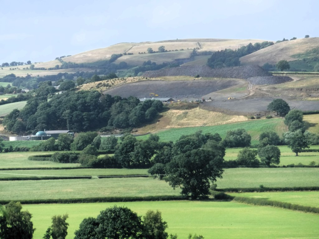
However, the listing concludes that: “In material terms …. nothing of historic interest has come to the attention of the archaeological records.” This may account for the fact that a somewhat weak Heritage Impact Assessment for the major expansion of a nearby intensive poultry unit operation (shown below) appeared to go unchallenged. Planning consent was granted in 2022 despite considerable opposition to this type of development, which has led to the modern county of Powys being labelled ‘the poultry capital of Wales.’ It is to be hoped that a current review 12 IPU applications by the Welsh government will lead to a more sustainable planning regime and that potential impacts of such facilities on the natural and historic environment will be given more weight in the future by the relevant statutory authorities.