
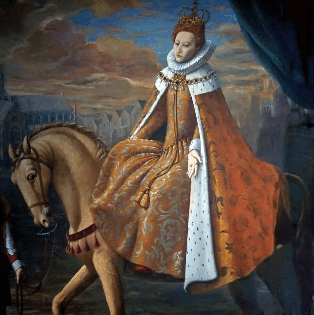
Whatever their views on the British monarchy, most people (including republicans it seems) were impressed by the pageantry of King Charles’ and Queen Camilla’s recent coronation, including its magnificent equestrian processions. Queen Elizabeth II was also famously associated with conservation of Britain’s equestrian heritage, including the nation’s horse and pony breeds. Aside from her patronage of thoroughbred race horses, the late queen supported the breeding of Cleveland Bays as well as Fell and Highland ponies The Anglo-Welsh Tudor dynasty too engaged in some famous equestrian patronage during the 16th century, when horses obviously played a far greater role in society. During the reigns of Henry VIII and Queen Elizabeth I a royal park and stud were established in the environs of the present day village of Caersws on the River Severn in North Powys (the former Mid Wales County of Montgomeryshire), with a second located at an unknown location near the borders of England and Wales (No.7 in the above map) known as The Marches (‘Y Mers’ in Welsh). This article considers some of the historical evidence for the royal horse park of ‘Eskermayne’ and the light it throws on the importance of Welsh equestrian heritage together with the landscape ecology of the Caersws Basin in Tudor and pre-industrial times before its late modern transformation.
Historical origins of ‘Eskermayne’
Some records for a property called ‘Esgir Maen’ (probable Welsh meaning ‘stone ridge’), Anglicised as ‘Eskermayne,’ go back to 1530 and can be found in a 2020 University of Wales Trinity St David PhD thesis by Heather Para on Monastic Development and Dissolution in Wales: Continuity or Change for Uchelwyr? (Page 302). The precise location of this landholding is unclear, but much of present day Caersws village is located on a ridge or ‘esker‘ beyond the River Severn flood plain. Coincidently, the absence of property records for ‘Eskermayne’ from the mid-16th century to 1625 are concurrent with the establishment of a royal park and stud in the Caersws area, probably enabled by Henry VIII’s Acts of Union and Dissolution of the Monastries together their landholdings. ‘Uchelwyr‘ are defined as gentry and “nobles descended from the pre-conquest native Welsh royal dynasties.” The contemporary writer Oliver Mathews claimed family association with the Caersws landholding known as Park Farm (see below) apparently used for the royal park, although this seems to have been disputed by other commentators. Nevertheless, Mathews’ account of the park’s establishment is a key source of information for the Tudor royal enterprise.
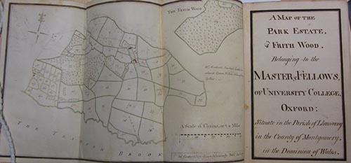
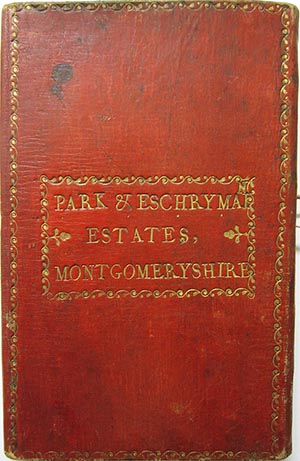
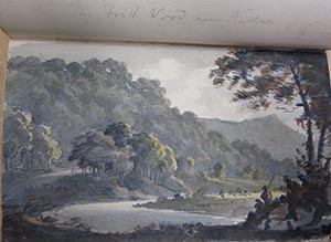
His and other accounts have more recently been corroborated in an archive compiled by Dr Robin Darwall-Smith of University College Oxford for a group of properties in the former manor of Arwystli in Montgomeryshire/North Powys bequeathed to the college by Robert Dudley, Earl of Leicester, on his death in 1588. A 2018 article by Dr Darwall-Smith which accompanies the archive refers to “a leather book” containing two late 18th century maps, plus “a charming water colour,” which describes the ‘Park and Eschrymain Estates’ (shown above). Whilst the main archive seems to identify ‘Escrhymain’ with various landholdings in the Severn Valley and Caersws Basin between Penstrowed and the Llanidloes area, the ‘Park Estate’ is clearly located to the west of Caersws (towards the village of Trefeglwys) and north of the ‘Trannon Brook’ (River Trannon). The topography of this location also includes the form of a distinct ridge (or esker) and the historic map identifies the contemporary landholding of ‘Park Farm’ (or ‘Coed Y Parc’) together with neighbouring properties in the general B4569 corridor. Here it seems probable was the royal park and stud of the Tudor dynasty.
Importance of Equestrian Sector
In an article on Horses and Equine Improvement in the Economy of Modern Wales by R J Moore-Colyer (Professor Emeritus, Aberystwyth University) in The Agricultural History Review (39, II, pp I26-I42) the author notes that: “Montgomeryshire stands alone in the context of the history of horse breeding in Wales.” He continues:
…. the heavy Montgomeryshire animals had probably originated from the royal stud at Caersws, established in the mid-sixteenth century with the object of breeding large, tractable horses for military purposes under the terms of Henry VIII’s various legislative measures. Around I540 it had been proposed that the park of Caersws, together with the farms of Penprise, be reserved and fenced for the King’s use, a task which could be accomplished at little cost since there was ‘a great plenty of oke’.*The officers drawing up the proposal outlined arrangements for the maintenance of 100 mares and 10 stallions of suitable size in the newly fenced park, and set out detailed instructions for the dispersal of their progeny. Like all emparkments the Caersws project did not proceed uncontested, with men of the mettle of the chronicler Oliver Mathews complaining of the ‘… given awaie of the parkes of Caerouse from the burgesses to keep the King’s breedinge mares’**
*State Papers (Domestic), Hen. VIII, vol Vll, 1574. ** Anon, Mont Coll, XVI, 1863, p 16
The article goes on to describe the subsequent operation of the royal stud and park, it’s later decline and significant equine heritage legacy:
….When Elizabeth I granted the manor of Arwystli to Robert Dudley, Earl of Leicester in I57I, the Caersws stud was in operation. Significantly, Dudley’s predecessor was William, Earl of Pembroke, Master of the Horse, who had probably held Arwystli on condition that he maintain the royal breeding stock.* The enthusiasm with which Dudley’s henchmen discharged their duty is open to question since William Harrison was prompted to note in I577 that however successful the King’s ‘noble studdery’ had been in the past, ‘the officers, waxing weary, procured a mixed brood of bastard races, whereby his good purpose came to little effect’.** Nevertheless, when the Montgomeryshire District Entire Horse Association set about improving local draught horses in the later nineteenth century, they were working with animals directly and collaterally descended from the royal foundation stock, which had steadily improved on the lush pastures and heavy soils of lowland Montgomeryshire.
* Calendar of Letters Patent, 1571 **Edelen, op cit, p 48.
Landscape of the Caersws Basin
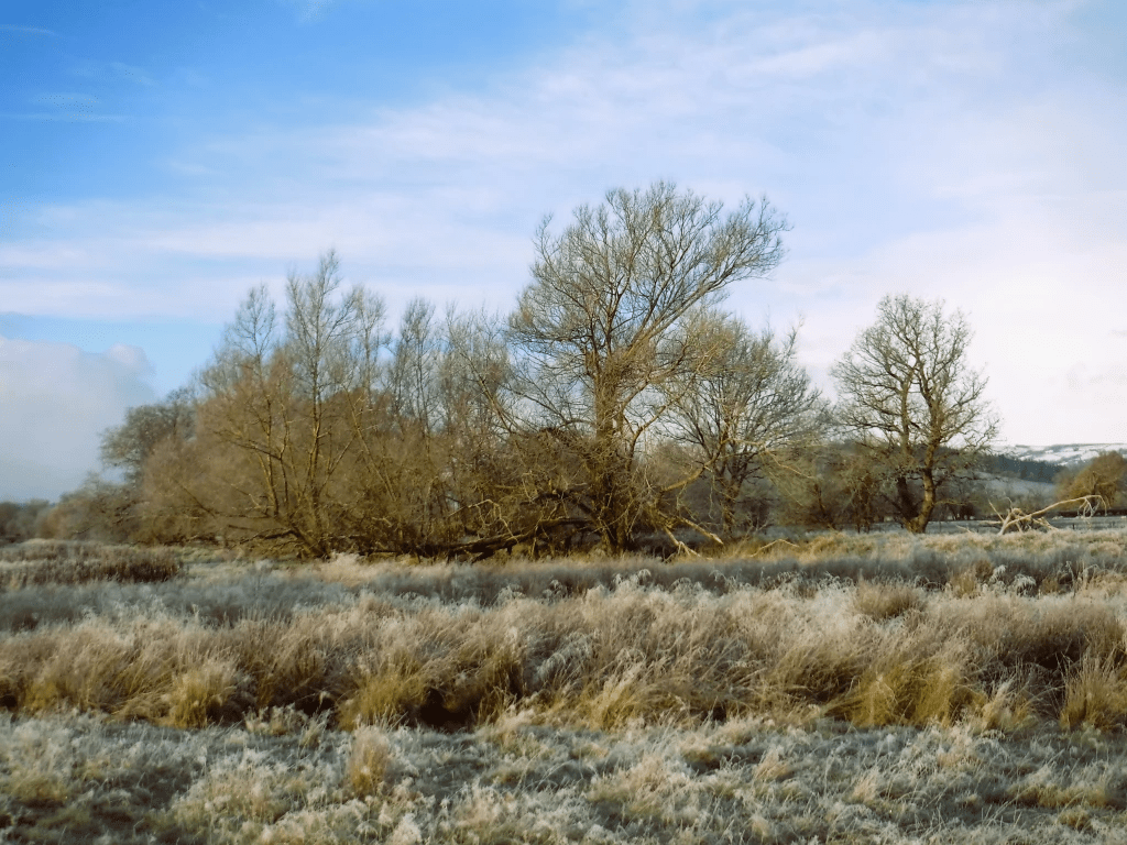
Extensive background information on the Caersws Basin (a registered historic landscape) can be found on the Clwyd Powys Archaeological Trust website (CPAT). A section on the ‘Post-Medieval and Modern period’ states that:
Renders paid by the tenants of the manor at Park (see above) in the early 13th century… make it clear that this was a hunting park in the Middle Ages, which was probably one of the reasons why it became a royal horse stud by the later 16th century… The earls of Pembroke had been granted all demesne, lands, and meadows in ‘Park Penprise’ in 1562, and it is probably significant that during this period William, earl of Pembroke and Robert, earl of Leicester, successively the steward and lord of Arwystli, also both held office of Master of the Horse. Powys had been a noted centre of horse breeding since the Middle Ages, Gerald of Wales surmising that the blood-stock in the later 12th century could be traced back to Spanish horses imported by the earl of Shrewsbury, in the late 11th or early 12th century.
The preceding limited but interesting accounts of the Caersws Basin’s equestrian heritage during the later medieval and early modern periods strongly make the strong case for further historical research; as does evolution of this landscape over a longer time frame given the need for greater resilience to climate change integrated with nature restoration. Information published by CPAT and other organisations evokes a vibrant mixed use landscape, dominated by wetlands, forests of oak and wood pasture maybe with similarities to the contemporary Windsor Great Park but in an, arguably, more spectacular location. Such work might build upon Exeter University’s Medieval Warhorse project:
…in the field of landscape history, the work has generated entirely new information about an aspect of the medieval countryside (the horse stud) that had been neglected. Over 800 medieval documents have been examined to provide information on the nature and organisation of studs, principally during the High Middle Ages. The project produced the first ever mapping of the English royal stud network, clarified the number and location of stud sites (within parks), characterised their landscape contexts (frequently in uplands or wetland zones), and reconstructed their hinterlands.
