
SEVERN VALLEY WATER MANAGEMENT SCHEME 2026 CONSULTATION SUBMISSION
The 21st century has been notable for a series of major flood events along the River Severn, impacting land and communities from Powys to its estuary in Gloucestershire. While the Severn Valley Water Management Scheme (SVWMS) is focussed on upper catchment settlements between Llanidloes and Shrewsbury, it is important to acknowledge the larger context. Although increased and more unpredictable rainfall (including periods of drought) linked to climate change is the salient cause of flooding, land management and urban development are also significant factors.(1) The following submission takes forward a discussion from March 2021 in the form of a blog entitled Severn Valley Water Management Options: from Re-engineering to Rewilding made available to the Environment Agency and other parties at the time.(2) While the present response welcomes the extensive public and stakeholder engagement, together with technical assessments – notably a landmark ‘Adaptation Pathways’ report last year – undertaken since 2020, key challenges remain around implementation of SVWMS.(3) Among these are finding a sustainable balance between ‘nature-based solutions and engineered interventions’, as highlighted by a major landholders group, and funding. (4)
This submission is structured as follows:
- Background to present SVWMS Concept and Components
- Catchment-based Approach and Demonstrator Projects
- Severn Valley Flood Alleviation Water Storage Area Options
- Emerging Strengths, Weaknesses, Threats, Opportunities
- The Case for ‘Semi-Rewilding’ of Severn Valley Floodplains
1. Background to present SVWMS Concept and Components

A June 2009 pre-feasibility report (Severn Valley Flood Risk Management Scheme -Phase 2) prepared for the Environment Agency by consulting engineers Jacobs provides some background to the SVWMS which has emerged since 2020.(5) It is noteworthy that the study area for the earlier scheme was ‘the river Severn’s natural floodplain from the River Vyrnwy confluence…to Worcester,’ rather than SVWMS’ upper catchment focus. The 2009 report was also based on the assumption that ‘… a flood control structure and dam, across the River Severn immediately upstream of Shrewsbury could be potentially viable.’ This possible scheme was given momentum by Shropshire County Council who suggested it might ‘be integrated with the Shrewsbury North West Relief Road (Relief Road), which was crossing the Severn valley at a location near the proposed structure.’ (see above image). Initially, the SVWMS that emerged in 2020 was, to use Jacobs’ expression, a ‘resurrection’ of the integrated dam and relief road option. However, the contentious nature of both components, particularly combined, together with serious financial viability concerns, meant neither progressed despite costly feasibility work.
2. Catchment-based Approach and Demonstrator Projects
A predecessor to what became known locally as the ‘Jacobs Scheme’ was the ‘Upper Severn Integrated Flood Relief and Wet Washlands Scheme (Wet Washlands Scheme),’ mentioned in the 2007 Shropshire Historic Landscape Character Assessment Final Report.(6) The report’s conclusion refers to an ‘Upper Severn Wet Washlands Group’ convened ‘to consider the feasibility of establishing wet washlands in the area.’ It notes that: ‘In 2003 EA drew up a long list of potential washlands and asked USWWG members for their views on what the likely environmental impact would be.’ The Wet Washlands Scheme seems to anticipate the broader catchment-based approach adopted by SVWMS in 2021. Described as ‘a wide programme of water management interventions that will be implemented across the Upper Severn Catchment,’ in the consultation linked to publication of a Sustainability Appraisal Scoping Report, SVWMS by now encompasses nature-based demonstrator projects and engineering options.(7)
3. Severn Valley Flood Alleviation Water Storage Area Options
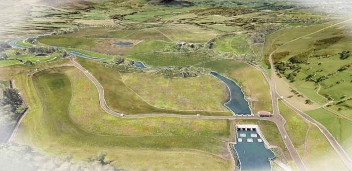
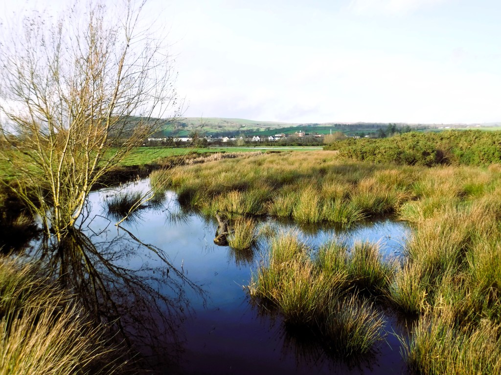
The preceding visualisation of a water storage area was used in a November 2025 Powys Council report on SVWMS discussed in various media coverage at the time.(8,9) This discussion suggested a possible location for the type of temporary storage area under consideration might be a section of the River Severn floodplains between Welshpool and Meifod, something confirmed in subsequent Powys consultations. Environment Agency officials at a Caersws event made comparisons with the Leeds Flood Alleviation Scheme which, albeit in a rather different context, combines engineered water storage and linear defences with catchment-based natural flood management.(10) A challenge for retaining flood water upstream between Llandinam and Caersws, another possible storage location identified, may be a combination of geology and fluvial geomorphology. Information is currently sought about recent work on these, as the main online source is a Joint Nature Conservation Committee report from the 1990s.(11) This report includes a chapter on Fluvial Landforms and Processes in Wales, with sections on the Upper River Severn between Dolwen and Penstrowed, and another on the River Severn between Welshpool and its confluence with the Vyrnwy. Flood waters typically move rapidly downstream from Llandinam-Caersws gravel beds, but as the names Welshpool /Y Trallwng (Welsh for ‘muddy pool’) suggest, can remain for long periods in this vicinity.
4. Emerging Strengths, Weaknesses, Opportunities, Threats
Evolution of water management schemes for the Upper Severn since the early 2000s imply what might be described as 3 non-exclusive ‘infrastructure’ scenarios: high (eg Shrewsbury combined dam and relief road); medium (wet washlands/water storage areas); and large-scale floodplain restoration linked to landscape recovery (see below). Although Strategic Environmental Assessment has become widely used over a similar timeframe for major programmes such SVWMS, SEA has not always been embedded in the process (sometimes called ‘optioneering’) whereby preferred options are selected, often leading to key challenges for their implementation. With this important caveat, it is nevertheless useful to review the emerging SVWMS using a basic SWOT analysis
Strengths
Over the past 5 years, SVWMS has brough together a strategic cross-border partnership led by the EA, with Natural Resources Wales, Shropshire and Powys Councils, the River Severn Partnership and National Flood Forum, with Arup as lead technical partner. The concept of ‘adaptation pathways’, defined as a ‘specific planning approach involving sequencing potential actions to respond to changing future risks and opportunities,’ provides a helpful way of framing the 3 infrastructure scenarios described above.(3) EA has demonstrated public engagement and use of SEA for river basin management.(12)
Weaknesses
In seeking to be consultative and inclusive, the SVWMS process has arguably become ‘bogged down’, when there is growing urgency for all stakeholders in water management to adapt to changes in climate and seasonal rainfall. Potential interventions need to be identified for the short, medium and longer terms according to their complexity and scale. The principle of subsidiarity must determine implementation responsibilities.
Opportunities
Integration of SVWMS with a range of statutory plans and programmes opens up potential funding opportunities and increases the likelihood that preferred options will be implemented. For instance, publication of Supplementary Planning Guidance for SVWMS to use with Local Development Plans is proposed, and it may be possible to access the budgets of private utilities and the transport sector for flood alleviation. Similarly, changes to agricultural funding regimes administered by the UK and Welsh governments to support nature positive climate adaptation are likely to be beneficial, as is the increasing availability of commercial (eg insurance) and philanthropic funds for these purposes. Partnerships with scientific research institutions may both strengthen the evidence-base of SVWMS and provide access to longer-term monitoring capacity.
Threats
There is widespread competition for public money, while so-called green finance does not yet have mechanisms for monetising improvements in flood risk management. The scale and cost of ‘high’ and ‘medium’ infrastructure scenarios implied by SVWMS raise significant challenges, and have met with local opposition in previous iterations. Some technical work may be insufficiently robust to withstand rigorous public scrutiny.
5. The Case for ‘Semi-Rewilding’ of Severn Valley Floodplains
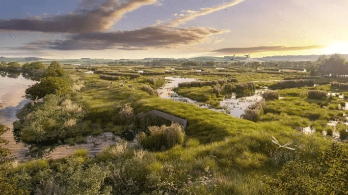
In the above context, and given ongoing assessment of possible locations for engineered water storage, it is recommended that SVWMS consider areas along the Upper River Severn where nature-based floodplain restoration programmes may be an option. A precedent for this approach is the ‘Eelscapes’ project for the Severn Vales floodplains between Tewkesbury and Gloucester, from which the above image is taken. This initiative is led by the Wildfowl and Wetlands Trust, Gloucestershire Wildlife Trust and the Environment Agency working in conjunction with over 25 landholders.(13) It has been developed as a ‘landscape recovery project’ for which UK government implementation funding became available last year.(14) Given the cross-border nature of SVWMS, Powys Severn Valley floodplains might also host a pilot. One potential location is the Upper River Severn corridor between Dolwen and Penstowed, perhaps focussed on the Caersws Basin or Caersws Valleys as identified in various Landscape Character Assessments.(11,15,16) Although the recent history of rewilding is not without controversy in Mid Wales, large-scale upland projects such as the one recently announced by Tir Natur are proceeding.(17) The Welsh Severn Valley could provide an opportunity for ‘semi-rewilding’ of water management linked to geomorphological processes, together with more resilient livestock-based farming systems.(18,19)
References
- https://www.reading.ac.uk/news/2025/Research-News/UKs-worst-case-climate-risks-laid-bare-for-lawmakers
- https://suisium.com/2021/03/08/severn-valley-water-management-options-from-re-engineering-to-rewilding
- https://engageenvironmentagency.uk.engagementhq.com/adaptation-pathway-programme
- https://www.cla.org.uk/cla-midlands-news/river-severn-catchment-management-consultation
- https://data.parliament.uk/DepositedPapers/Files/DEP2010-0588/DEP2010-0588.pdf
- https://next.shropshire.gov.uk/media/rggjispl/historic-landscape-character-assessment.pdf
- https://storymaps.arcgis.com/stories/4c59daa19b074aa9b5fe20fc6554d4fb
- https://powys.moderngov.co.uk/mgConvert2PDF.aspx?ID=99908
- https://nation.cymru/news/support-grows-for-severn-water-scheme
- https://www.ice.org.uk/what-is-civil-engineering/infrastructure-projects/leeds-flood-alleviation-scheme-phase-2
- https://data.jncc.gov.uk/data/8f95d26e-19cf-4b84-abd5-6f3e0df36354/gcr-v13-fluvial-geomorphology-of-great-britain-c3.pdf
- https://www.gov.uk/government/publications/strategic-environmental-assessment-of-river-basin-management-plans-scoping-reports
- https://storymaps.arcgis.com/stories/3f4a1b6797434bdcbfe555f8bff1a1df
- https://defrafarming.blog.gov.uk/2025/08/29/landscape-recovery-first-projects-move-into-delivery-phase.
- https://heneb.org.uk/hcla/the-caersws-basin
- https://en.powys.gov.uk/article/13413/Landscape-Character-Assessment-Profiles
- https://www.tirnatur.cymru/the-land
- https://doi.org/10.3390/wild3010006
- https://www.sciencedirect.com/science/article/pii/S0308521X22000464
